|
Ardnamurchen Peninsula
This extraordinary part of Scotland is a pleasure to visit, wonderful scenery and very remote.
CLICK HERE
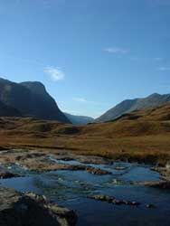
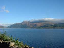
Glencoe
Steeped in history and a place that most visitors head to when in Scotland. It is a beautiful bit of scenery.
CLICK HERE
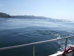
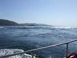
Gulf of Corryvreckan
Seeing is believing this is the second largest whirlpool in the world and is phenominal.
CLICK HERE
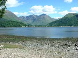
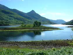
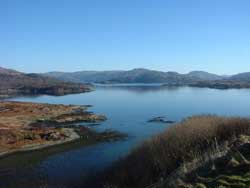
Loch Leven - Lochaber
Travel round this spectacular loch and visit the village of Kinlochleven at the end of it.
CLICK HERE
Loch Lomond
A tourist attraction if their ever was one in Scotland, the Bonnie Bonnie Banks are a wonderful sight.
CLICK HERE
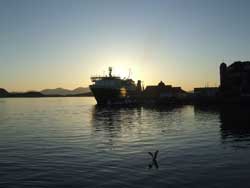
Mallaig
Known as the Road to the Isles, A busy fishing town with ferries to various Islands.
CLICK HERE
Morar Sands & Loch Morar
Visit the white sands at Morar and enjoy a trip to see the beautiful Loch Morar.
CLICK HERE
Mull of Kintyre
Enjoy the crashing waves and beaches, along with some phenominal scenery as you drive down this peninsular.
CLICK HERE
Oban
Oban is a picturesque town, ferries leave here for the islands and is a great place for shopping.
CLICK HERE
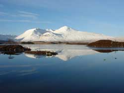
Rannoch Moor
One of the most desolate yet spectacular places to visit in Scotland, no matter what time of year.
CLICK HERE
|
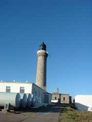
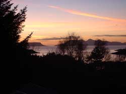
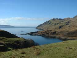
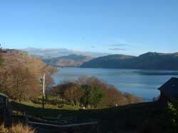
The Ardnamurchan peninsula is on the remote West Coast of Scotland and is inhabited by less than 2000 people. It measures 50 square miles and is a narrow peninsular it is unpolluted, unhurried and uncrowded. The lighthouse at Ardnamurchan Point is the most westerly part of the British mainland. It is home to thousands of animals including red deer , seals, otters, pine martens and even eagles. The plant life is extraordinary and there are some very rare species.
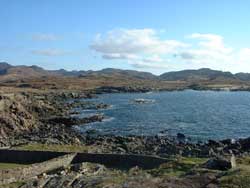
As you drive towards the Point you have Loch Sunart to your left and this is a beautiful loch full of surprising scenery. At times it will take your breath away as it is a fabulous route through a real remote part of Scotland. |
|
Then as you look to the coast to your right you see in the distance the islands of Eigg, Muck and Rum. On our journey we enjoyed the stillness of the area. |
|
Ardnamurchan may appear, today, to be rather a peaceful, quite and remote corner of Scotland . However, the fact that it is a peninsula on the west coast with poor land access made it ideal for the "power barons" of the past. A base on this peninsula could be a highly important strategic fortification for overseeing activities in Mull , Skye, the Argyll coast and even as far as the Western Isles. |
This is why the Vikings landed here and stayed for over 500 years - the names Placaig, Acarsaig, Ormsaig and Grigadale are all Norse in origin.But they were not the first settlers on the peninsula - there is evidence of ancient settlers going back 4,000 years.
The Vikings finally left Ardnamurchan in the mid 13th century having been challenged by a Scot called Somerled. The Vikings, once settlers, now became invaders and their rule came to an end with the assassination of the tyrannical ruler Muchdragon MacRi Lochlunn in 1266. He was slain on the slopes of Ben Hiant by one of his vassals Evun Cleireach. There are a few local landmarks to the north and west of Ben Hiant whose origins come from Evun's name. |
With the demise of Viking rule, Ardnamurchan became part of the feudal holdings of the Scottish King David II. Mingary Castle was built around this time (circa 1400) and it served the needs of the Lords of the Isles against the wishes of the Crown. Feuding was common and the Crown found Ardnamurchan difficult to control. 3 expeditions tried to quell these feuds but all failed. |
|
|
| Back to Top |
When Angus, Lord of the Isles was assassinated in 1490, John MacIan, the new Chief of the MacIans, decided to favour the Crown and King James IV visited the Castle in 1493. However, John MacIan soon fell out of favour but managed to redeem himself and was finally given the lands of Ardnamurchan in 1499 - redeeming himself in the eyes of the Crown but falling out with the other Islanders!
In 1513, King James IV was killed at Flodden leaving a very young son as King. As a result of the Crown's perceived weakness, feuds again enveloped the highlands and islands. Mingary Castle was besieged in 1515 and again in 1517 when it was eventually destroyed by Sir Donald MacDonald of Lochalsh. The Castle was re-built by MacIan but a further battle just south of Craig-an-Airgid (GR 474665) in 1519 put paid to MacIan and his two sons who are buried near this spot. |
 |
MacIan's grand-daughter, Mariada, finally disposed of Ardnamurchan to Archibald, the 4th Earl of Argyll in 1540. In 1588, however, we find another, older, John MacIan residing at Mingary. The Castle was again besieged for 3 days by the MacLeans of Mull. Common sense seems to have broken out at this stage and the feuding families appear to have come to an agreement to end this particular feud but it was the start of another, with the Campbells this time, who eventually dispossessed the MacIans in 1626. |
The MacIans were hunted down and most of them killed in Morvern after a spate of piracy!
In 1628 the Castle passed into the hands of Sir Donald Campbell but nothing of note appears to happen after 1644 although the structure was still inhabited in 1838.
In July 1745, Bonnie Prince Charlie landed at Loch nan Uamh near Arisaig and immediately set off for Kinlochmoidart. Being a Hanoverian, Campbell , stronghold, his presence in this parish was not welcome by the local minister in Kilchoan although it was by many of his parishioners. He very quickly broke the news to the Sheriff in Inveraray. Dalilea was the nearest the Bonnie Prince came to Ardnamurchan preferring to hide in the more welcoming realms of Lochaber.
After the '45 rising and to a certain extent, as a result of it, the Highland Clearances took hold in the Highlands and Islands and Ardnamurchan was not spared. In 1828 the townships of Coire-mhuilinn, Skinod, Buarblaig and Tornamona were cleared and in 1853, the Swordle townships.
|
Since then the estate has been sold several times, sometimes in parcels until today when the estate now consists of the central third of the peninsula instead of the whole peninsula as in the mid 19th century.
The history of this remote area of west coast Scotland is fascinating, sometimes harsh and violent and often sad but, above all, it has been highly prized not only by the power barons of medieval times but by the people it has housed, sheltered and sustained over the centuries. |
 |
|
| |
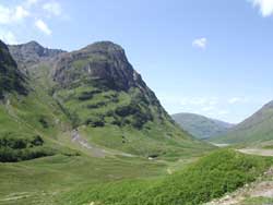
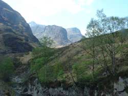
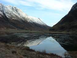
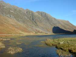
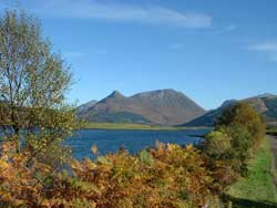
Glen Coe is a steep-sided valley climbing steadily south east from the village of Glencoe on the sea-loch, Loch Leven. It eventually emerges from its enveloping mountains onto the wet plateau of Rannoch Moor ten miles away and at an altitude of over 1000 feet. It is one of the most famous of Scotlands beautiful glens.
Glencoe is steeped in mystery and horror. Not just for its dramatic location but because of the evil deeds that were commited there in the name of King William III of Orange. |
|
The name probably means narrow glen and for the sheer beauty and majesty of its mountain scenery there is little to beat it anywhere in this world. The north side of the glen is closely hemmed in by the jagged edge of the Aonach Eagach ridge, usually thought to be the most challenging ridge scramble in mainland Scotland.
The south side of lower Glen Coe, is governed by Bidean nam Bian, a huge giant of a mountain that hides behind the trio of butresses that lord over the famous glen. Hidden behind two of these huge rocks lies the high level valley of Allt Coire Gabhail, for many years used by the Glen Coe MacDonalds to hide their cattle, and anyone else's they could get their hands on.
Glencoe is known throughout history for the massacre that took place there at 5 o'clock on the morning of 13 th February 1692, when 38 MacDonalds were murdered, not as history tells you by Campbells but on the authority of the crown. |
 |
There were Campbells among the soldiers who massacred the 38 people but this was not a Campbell clan attack.
There had been bad blood between the MacDonald and Campbell clans for many years. The MacDonalds were regarded as thieves and cattle rustlers, by the Campbells and most other clans in that location. |
If we go back as far as 1501, then we can asses the conflict between the two clans. In that year the MacDonalds captured a Campbell castle on an island in Loch Awe, and over the following 150 years many minor raids were to follow. These raids included the one in which 30 MacDonalds were caught and hanged in Glen Lyon for being cattle rustlers. In 1646 a MacDonald raid into Glen Lyon led to the deaths of 36 Campbells and Menzies after a wedding. 1685 saw the Atholl Raid, in which Glen Coe MacDonalds laid waste to large parts of Glen Lyon. And in 1689 they burned down Achallader Castle, near Bridge of Orchy, in another skirmish with the Campbells. There was plenty of history between the warring clans before the infamous 13 th of February incident.
So how did the MacDonalds become victims of this massacre you may ask?
William III of Orange wanted to bring the clans into line and In August 1691 he offered to pardon all the Highland clans who had taken up arms against him in the 1689 Jacobite uprising. These included the Glen Coe MacDonalds. The pardon was conditional on their taking an oath of allegiance to him by 1 January 1692. |
Clan Chief Alastair MacDonald arrived at Inverlochy (now Fort William) on 31 December 1691, only to find he should have gone instead to Inveraray to take his oath. He eventually got there five days late. As a result, the Glen Coe MacDonalds did not appear on the list of clans who had taken the oath by the deadline.
This had been a deliberate plan by the crown to choose a scapegoat. They wanted a clan to make an example of and the MacDonalds, unfortunately for them were the chosen ones. |
|
The signing of the alligiance was made so complex that Alastair MacDonald, had no chance of ever being able to put his name to it. When he went one place they pointed him to another, and in the cold of a bitter winter this was an impossible task to perform.
The crown then recruited a Captain Robert Campbell to take a troop of approximately 130 men into the glen on the pretext of seeking shelter and lodgings. |
 |
He was probably put in charge because he was unlikely to question his orders. He was a bankrupt and said to be an alcoholic. It has been suggested that he was offered his debits be cleared and he would be givcen a good pension to perform his hidious task.These duly arrived, in writing, on 12 February, from Major Robert Duncanson based at Inverlochy. Captain Campbell and his men were to "fall upon the Rebells... and putt all to the sword under seventy." |
As history recalls at 5A.M. on the morning in question a fire was seen on what is now known as signal rock, this started the massacre. There were up to 500 MacDonalds, scattered over the lower reaches of Glen Coe. The massacre was ineptly carried out. Some 38 MacDonalds were killed by the troops, but the sound of the initial gunfire provide ample warning to most, who escaped into the winter mountains. An unknown number subsequently died from exposure. One thing that was in the MacDonalds favor was that people sent to block the mountain escape paths did not make it to them because of the bad weather.
When news of the murder in the glen spread, there was a public outcry and the then Secretary of State for Scotland Sir John Dalrymple, had to resign. The officers who commanded the troops in the glen carried on with their military careers as normal. Camptain Robert Campbell ended his days lying in a gutter in Bruges. This was a fitting tribute to a soldier who had taken part in one of the darkest days in Scottish history. |
What offended Highlanders most about Glen Coe was the abuse of the hospitality offered by the MacDonalds to the government troops.
If the crown could cold bloodedly murder people who treated them as guests, what would they do to an enemy?
This was not a Campbell MacDonald issue, Glen Coe had less to do with clan rivalries than it had to do with the government's continuing efforts to suppress the Highlands and its troublesome residents. The orders for the massacre were signed by a Major in Inverlochy, but the action was authorised all the way up to the Secretary of State for Scotland and beyond, probably to the King himself. |
|
Glencoe is a wonderful place to visit, and stay. It is a very mysterious glen and appears to be watching you at all times.
There is a story that on certain nights of the year you can hear the ghostly cries of the people being murdered and thrown into the snow by a cruel enemy. |
|
| Back to Top |
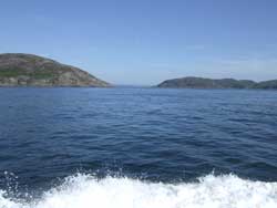
| This is a must to go and see, it is a phenomenen that will blow you away. The trip from Balvicar by Sealife Adventures was a fantastic experience. The family owned business are very helpful and take a lot of pride in informing you of historical and sea life stories. As you venture through the Corryvreckan the water in the whirlpools seems like cream, also there is a stillness and a calm about the place. During this trip the engines were stopped and we went with the huge swell. |
|
| The Gulf of Corryvreckan (from the Gaelic Coirebhreacain meaning "cauldron of the speckled seas" or "cauldron of the plaid"), also called the Strait of Corryvreckan , is a narrow strait between the islands of Jura and Scarba , in Argyll and Bute , off the west coast of Scotland . |
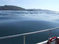 |
Strong Atlantic currents and unusual underwater topography conspire to produce a particularly intense tidal race in the channel. As the flood tide enters the narrow area between the two islands it speeds up to 8.5 knots (16 km/h), and also meets a variety of seabed features including a deep hole and a rising pinnacle. These features combine to create whirlpools , standing waves and a variety of other surface effects. |
The Corryvreckan is the third largest whirlpool in the world, and is on the northern side of the gulf, surrounding a pyramid-shaped basalt pinnacle that rises from depths of 70 m to 29 m at its rounded top. Flood tides and inflow from the Firth of Lorne to the west can drive the waters of Corryvreckan to waves of over 30 feet (9 m), and the roar of the resulting maelstrom can be heard ten miles (16 km) away.
The area is currently being considered for Special Area of Conservation status. Minke whales and porpoises swim in the fast-moving waters and only the most resilient plants and corals thrive on the seabed . |
| Scottish mythology has it that the hag goddess Cailleach Beara uses the gulf to wash her plaid ; the whirlpool was her washtub. By winter the cloth was white, and became the white blanket of snow that falls over Scotland in January. Another legend surrounds Norse king Breachan . In various stories, Breachan moored his boat near the whirlpool to impress a local princess, or fled his father across the gulf. |
|
In both stories Breachan was swept into the whirlpool, and his body dragged ashore later by his dog. Breachan may be named after the whirlpool, or its current name may be a Gaelic pun on his name. Writing in the 7th century Adamnan called it " Charybdis Brecani".
|
 |
Formerly classified by the Admiralty as unnavigable (the Admiralty's West Coast of Scotland Pilot) guide to inshore waters still calls it "very violent and dangerous" and says "no vessel should then attempt this passage without local knowledge"), its treacherous waters are nevertheless still sailed and swum by a few hardy adventurers. Writer George Orwell and his son (who lived at Barnhill in northern Jura) were briefly shipwrecked on the skerry of Eilean Mor (south of the whirlpool) when boating the gulf, and Orwell's one-legged brother-in-law Bill Dunn was the first person to swim the gulf. |
|
| Back to Top |
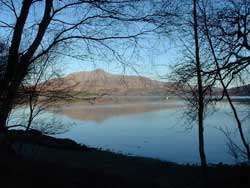
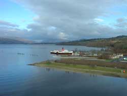
If ever there was a loch that had everything then I believe this is it Loch Leven in the Highlands. It has outstanding scenery and as you drive round the loch you have the chance on the north side to be virtually at loch level, but when you travel along the south side you are at a considerable height. Do not forget to do this little journey as it is exquisite and it is so easy to just go over the Ballachullish Bridge and forget to go to Kinlochleven. |
|
 |
Loch Leven extends 14 kilometers, varying in width between 200 and 1800 meters. It opens onto Ballachulish Bay, part of Loch Linnhe at its western end. There are seven small islands, some rocky and covered with heather and some just smooth green grass, near the western end of the loch.
|
| The village of Glencoe lies on its southern shore and you manage to get some spectacular photographs from the northern shore. The burial place of the MacDonald clan of Glencoe lies on an island - Eilean a' Munda, or St Mungo's Island, opposite the village. The island burial place was also shared by the Camerons of Callart on the north shore of the loch. |
|
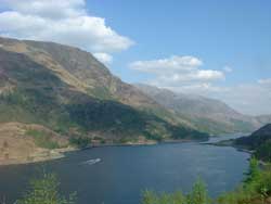 |
The village of Kinlochleven lies at the head of the loch. It originally lay on the road north to Fort William which followed the shores of the loch, but a bridge was built across the mouth of the loch at Ballachulish in 1975.
Under the Ballachulish Bridge, at the entrance to the loch, is the narrows after which Ballachulish (the settlement on the narrows) is named. There is a fast tidal stream through the narrows, running at up to seven knots at springs; it is wise, therefore, to time any passage through the narrows with the tides. |
Further up the loch, there are several other narrows with significant, but diminishing tidal streams. The loch is navigable as far as Kinlochleven, and was used by ships bringing bauxite to the smelter there until its closure. |
|
| Back to Top |
Loch Lomond is probably the worlds most famous Loch and has been extensively written about, both in song and verse. This area is renowned for its beauty and tranquillity, visited by thousands of tourists every year and offers picture postcard views around every corner.
Just 20 miles from Glasgow it is the start of the highlands and is beautiful no matter what season of the year you visit. |
|
On the Loch there are approximately 38 Islands , some of them inhabited and there is even a Hotel on Inchmurrin. |
 |
It is an ideal place to stay for your holidays as you have the highlands to the north and of course the magnificent west coast just a few miles away. I am sure you will be blown away by the scenery as you travel the length of the Loch .
There are plenty of cruise boats that go up and down the loch from either Tarbet or Balloch, this is a fantastic way to take in the splendour of Loch Lomond . |
| The Loch is crossed by the Highland Boundary Fault and exhibits the physical characteristics of both highland and Lowland Scotland. Some 200 species of birds and over 25% of Britain 's wild plants have been recorded in the area.
You will never be disapointed with Loch Lomond and please call into Luss and take in this wee village of absolute charm and beauty. |
 |
|
| |
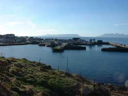
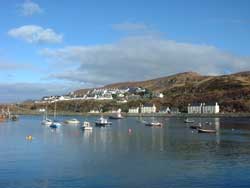
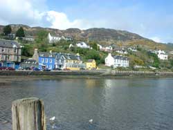
Mallaig is a fishing port situated some 150 miles north of Glasgow, it has roughly 1000 inhabitants and is known as you travel towards Mallaig as The Road to the Isles.
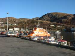
Mallaig was once Europe's busiest herring port although nowadays it is however still a major fishing town landing large catches of prawns and other shellfish. It is also the most westerly harbour on the British mainland and plays a very important role as a lifeboat station for the region. |
|
 |
Some 1500 years ago the area was a buffer zone, It was squeezed between the kingdom of the Picts and the maritime kingdom of the Norsemen. Longships from the Norse gave way to Highland Galleys as the area became part of the Hebridean Lordship of the Isles, and consiquently didn't come under full control until 16 th century of the Scottish Crown. |
The area itself retains it's character and it is unique and visitors return regularly to enjoy the splendid coastal and mountain scenery with pure white sandy beaches. Is there any wonder why the railway journey to Mallaig is classed as one of the most spectacular in Europe.
In Mallaig you can board ferries to many of the islands including Skye, Rum Eigg and Muck. |
|
|
| Back to Top |
 |
The road north towards Mallaig is a tremendous drive as you pass Arisaig and although still partly a single track road, the views of the seascape are formiddable. Over the turquoise sea and white sandy beaches you see the islands of Eigg and Rum and further north towards Skye. This stretch of coast was used in the film Local Hero and is known as the Silver Sands of Morar. |
| The River Morar estuary itself is an unbelievable beauty spot with its white sandy beaches and blue water of the Caribbean nature. |
If you are fortunate enough to come here at low tide the estuary itself is almost covered over by the white sand. The River Morar is the smallest river in the UK just a mere 400 yards long as it flows out of Loch Morar.
Many people just pass the Morar sands and forget to take the tiny road for a few miles along the impressive Loch Morar. It is a dead end after about three miles but is well worth the effort to go and see. |
|
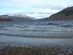
Loch Morar is the deepest lake in the British isles with a maximum depth of 310.0 m and ranks seventeenth deepest in the world. |
 |
Owing to its remoteness and accessibility the beast in these waters is harder to see. No doubt if we had more visitors there we would have more sightings.Its alleged resident beastie has been dubbed Morag.
This is a journey of unforgetable beauty and you will need plenty of memory on your cameras to film all you see around here. |
|
| Back to Top |
On the South western tip of Argyll is a peninsular known as The Mull of Kintyre. Probably made more famous in recent times by Paul McCartney's song about the region. Paul lives just outside Campbletown and enjoys how the mist comes rolling in from the sea.
Campbletown is the main town which has a farming and fishing industry although the main industry is the distilling of Whisky. This is home of some of the best whisky in the world, especially the award winning "Springbank. |
|
 |
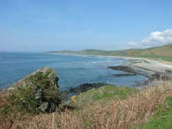
The region itself is a narrow piece of land stretching from Tarbert with mountains in the middle and surrounded by farmland down to the coast and southern most tip of Southend. Its history dates back to the Vikings that once lived here. You have the chance on the eastern side of the Mull to see some stunning views of the Isle of Arran. On the western side you have fantastic scenes across to the islands of Gigha, Jura and Islay. |
The coastline is breathtaking at times with large surfs from the Atlantic Ocean hitting the sands and rocks on the coast.
The wide range of wildlife you will find here is astounding. Probably due to the isolation of the area, many species of animals roam freely here and during one short trip nature lovers can expect to see almost as many animals living in their natural habitat as they would find in a zoo. |
|
 |
This area is a paradise for walkers, no matter what skill level you have. You can walk along the beach or stroll through the pristine forests, but the more adventurous can indulge in a strenuous climb on the cliffs and along the rocky shores.
Since August 2006 there is a walk the Kintyre Way from Tarbet to Southend in the south of the peninsular which will take you roughly 4-7 days to complete. |
|
| Back to Top |
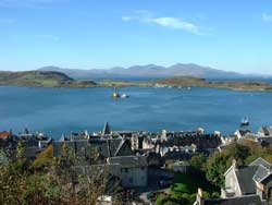
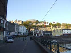
Oban is justifiably known as the Gateway to the Isles. The town's south pier is the embarkation point for car ferries to Mull, Coll, Tiree, Barra, South Uist, Colonsay, Lismore and Islay. From these islands you can travel further afield to Iona, Staffa and to many of the smaller less well known isles.
There is plenty to do in Oban, with great wee shops and of course great food in the many restaurants.
|
|
 |
And it doesn't stop there. A short distance from the south pier along the Gallanach Road is the slipway for the Kerrera ferry, and a pleasant drive south allows you to take your car, or bike, over the Atlantic by bridge to the Island of Seil.
Travelling to Oban, on the west coast of Scotland, is a joy. Around three hours by car, coach or train from Glasgow or Edinburgh, less than 2 hours from Stirling, the scenic journey is a memorable part of a visit to this bustling sea side town.
|
Oban is easily reached from Central Scotland by taking the A82 which skirts the west side of Loch Lomond. Then either via Tyndrum or follow the A83 over the 'Rest and be Thankful' through Inveraray. Both journeys take between 2 and 3 hours, although you may be tempted to stop several times to admire the scenery.
You will enjoy a journey to Oban and take in all this seaside town has to offer. |
|
|
| Back to Top |
Rannoch Moor is a wild sombre place when the rain and wind blow, it is barren and desolate yet in the good weather it is a gorgeous place to visit, with it's shining wee lochs with treeclad islets and sandy bays in amongst the grass and purple heather . The views of the surrounding mountainous areas are a delight to see. Just two hours from Edinburgh and Glasgow yet here you live in another world and even time zone, it's tranquillity on a fine day is tremendous. |
|
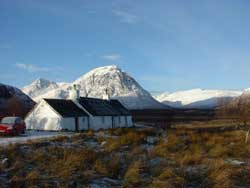 |
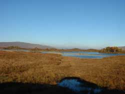
It covers some 20 square miles at a height of over a 1000 feet of peat and bog for the most part, laid on granite. It is the Watershed of Central Scotland where rivers start their journeys towards the Atlantic in the west and to the North Sea in the east. Over this area are scattered thousands or enormous rocks which have been torn from the sides of the hills and corries by a giant glacier moving eastwards 20,000 years ago. |
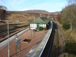
No road connects the west and east side of the moor. Although there is a station on the east side called Rannoch Station, it is only accessable by road from Pitlochry on the B8019 past Loch Tummel then via the B846 atTummel Bridge through Kinloch Rannoch and up past Loch Rannoch. The railway which bisects the moor, took 5000 navvies and nearly five years to build, a task made nearly impossible by the problem of peat and water. |
|
| The peat had to be overlaid with brushwood, tree roots and thousands of tons of ash so that the permanent way could be floated across. |
 |
The lochs on the moor are good for trout and the sandy shores and the islets attract interesting birds, such as the black-throated diver, goosander and merganser, while on the heather slopes are curlew and red grouse. Higher up, mountain hares and red deer may be spotted, and with luck, the traveller may see a golden eagle or osprey. Even the boggy stretches are not void of interest. There is an abundance of sweet smelling bog-myrtle and the rare Rannoch Rush can be found, the latter a delicate little plant grown no-where else in Britain . |
|
Back to Top
|